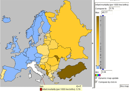
Unclassed Choropleth maps portray areal data without the use of classes. Instead of using classes this style of map contains as many intervals as there are areal units. This type of choropleth map allows small changes in data to be displayed under its own color. It uses a color ramp or scale to measure the changes. With the amount of data sometimes being overwhelming, it is possible that this style of map is sometimes hard for the viewer to distinguish between areas containing different values. This map is showing the infant mortality rate, per 1000 live births, in Europe compared to Italy. Darker colors have a higher mortality rate than lighter colors in the "brown" section. Blue areas are countries that have a lower infant mortality rate than Italy.
No comments:
Post a Comment